GEOTECHNICAL ENGINEERING
NEWARK
HomeGeophysicsElectrical resistivity / VES (Vertical Electrical Sounding)

Electrical Resistivity Testing (VES) for Newark Construction Projects

Evidence-based design. Reliable delivery.

LEARN MORE

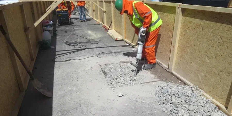
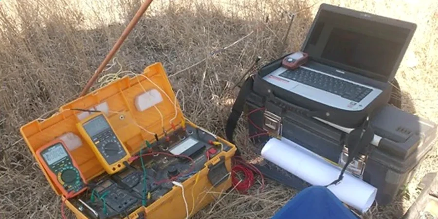
The International Building Code, as adopted by Newark, places a clear responsibility on the geotechnical engineer to characterize subsurface conditions before foundation design begins. In a city where 250-year-old brick sewers share space with brownfield parcels and buried estuarine clay, relying on a handful of boreholes leaves dangerous blind spots. The electrical resistivity / VES (vertical electrical sounding) method fills those gaps. By injecting a known current into the ground and measuring the resulting potential difference, the equipment maps how easily the soil transmits electricity. That property, resistivity, shifts dramatically between dry sand, saturated silt, saltwater-influenced clay, and hydrocarbon contamination. Newark's location along the Passaic River and Newark Bay means the water table sits high, and saline intrusion isn't theoretical, it shows up in the data. The survey delivers a continuous profile of subsurface layering, which helps the design team position additional SPT drilling exactly where the geophysics indicates a transition, not where the grid says a boring should go.

In Newark's brownfield corridors, resistivity soundings often catch a sharp conductivity spike at the fill-native interface that conventional borings miss entirely.

Our service areas

How we work

We ran a VES line behind a warehouse off Doremus Avenue where the developer needed to confirm if a historic fill layer extended deeper than the planned footing elevation. The resistivity curve showed a sharp drop from 80 ohm-m in the upper dry fill to below 5 ohm-m at nine meters. That low-resistivity zone matched the depth where pore water from the Passaic tidal influence saturated a layer of fine-grained dredge material. Knowing that before excavation let the shoring designer specify a tighter sheet pile interlock and stage the dewatering in lifts. The survey uses a Schlumberger array with expanding electrode spacing, typically AB/2 from 1.5 meters out to 100 meters, so the current penetrates progressively deeper. Crews can complete a full sounding in under two hours on a paved lot, faster on open ground. Data interpretation follows the partial curve matching technique refined by Orellana and Mooney, then runs through a layered inversion model to produce true resistivity versus depth. The result is a stack of geoelectric layers that correlates directly with grain-size changes, perched water, or the base of an old municipal ash fill. For projects that also need small-strain stiffness, the same crew can perform a MASW survey along the same line, pairing resistivity stratigraphy with shear wave velocity in a single mobilization.
Electrical Resistivity Testing (VES) for Newark Construction Projects
Technical reference — Newark

Local geotechnical context

Newark has a split personality when it comes to soil moisture. The eastern half of the city, from Ironbound down to the port terminals, sits on artificial fill over estuarine deposits where groundwater is tidally influenced and the pore water is conductive enough to short-circuit resistivity contrasts if the survey isn't timed carefully. The western neighborhoods, up toward the First Watchung Mountain slope, deal with residual sandstone saprolite and perched water that can create a false bedrock signature on a raw apparent resistivity curve. Without a layered inversion that accounts for equivalence and suppression, a contractor might drill expecting refusal at six meters and find weathered shale that keeps going to twelve. The risk isn't just depth error. In areas with buried steel, reinforced concrete foundations from demolished factories, or active cathodic protection on gas lines, the injected current can channel along the metal and give a completely misleading low-resistivity reading that gets interpreted as groundwater contamination. That's why every VES report from our team includes a cultural interference log and, when necessary, a time-domain induced polarization check to separate metallic conductors from clay-rich aquitards.

Need a geotechnical assessment?

Reply within 24h.

Email: contact@geotechnical-engineering.vip

Relevant standards

ASCE 7-22 (Minimum Design Loads and Associated Criteria for Buildings and Other Structures), Section 20.3, IBC 2021 (International Building Code), Section 1803 – Geotechnical Investigations, ASTM D6431-18 (Standard Guide for Using the Direct Current Resistivity Method for Subsurface Site Characterization), ASTM D2487-17 (Standard Practice for Classification of Soils for Engineering Purposes – Unified Soil Classification System), ASTM D1586-18 (Standard Test Method for Standard Penetration Test and Split-Barrel Sampling of Soils)

Technical data

ParameterTypical value
Array configurationSchlumberger (standard); Wenner available on request
Maximum investigation depth100 m (typical AB/2 max = 100 m)
Current injectionUp to 400 V DC, constant-current regulated transmitter
Data acquisitionStacked readings with automatic standard deviation check, < 3% error tolerance
Inversion methodLayered 1D inversion with smoothness-constrained regularization
Output deliverablesLog-log apparent resistivity curve, interpreted geoelectric profile, 2D pseudosection (if multi-station)
Reporting standardASCE 7-22 Section 20.3, IBC 2021 Section 1803, ASTM D6431-18
Typical project durationFieldwork 1-2 days; report in 4-5 business days

Common questions

What does an electrical resistivity test in Newark typically cost?

For a single-location vertical electrical sounding with a Schlumberger array and a standard investigation depth up to 100 meters, the cost ranges from US$540 to US$1,170 depending on site access, the need for traffic control, and the number of expansion cycles required. A 2D resistivity imaging transect with multiple stations along a line runs higher because of the additional field time and inversion processing. Every quote includes data interpretation and a signed, seal-ready geophysical report.

How deep can resistivity testing see in the Newark area?

The rule of thumb is that the maximum depth of investigation reaches roughly one-third to one-half of the total current-electrode separation. With a maximum AB/2 of 100 meters, we typically resolve layers down to 50 meters. In the meadowlands, where conductive silts attenuate the signal, effective depth may be shallower; on the drier glacial till uplands west of Branch Brook Park, the same spread can see deeper. The layered inversion report always states the depth of investigation for that specific sounding.

Can you run resistivity lines on asphalt or concrete?

Yes, with some preparation. On asphalt pavement, we use a small rotary hammer to drill pencil-sized holes through the pavement section so the stainless-steel electrodes make direct contact with the underlying soil. Each pinhole gets backfilled with bentonite slurry to maintain electrical coupling. On reinforced concrete slabs, the rebar can create a short-circuit effect that distorts the readings, so we either avoid those locations or use a dipole-dipole array and process the data to flag metallic interference.

How do you tell the difference between clay and contaminated groundwater on a resistivity profile?

Both clay and saline or hydrocarbon-impacted groundwater produce low resistivity values, and that ambiguity is the classic limitation of the DC resistivity method. In Newark's brownfield sites, we resolve this by running an induced polarization chargeability measurement on the same array. Clay has a measurable chargeability response, while dissolved-phase contamination typically does not. Where the budget allows, we also recommend pairing the resistivity transect with one or two cone penetration tests with electrical conductivity modules to provide ground-truth at specific points along the line.

Location and service area

We serve projects in Newark and surrounding areas.

View larger map